All EOS blogs All Spain blogs  Start your own blog Start your own blog 

Max Abroad : The Best of Spain

Quite simply writing about the best things Spain has to offer and anything that might crop up along the way. Spain is a lot more than just sun, sand and sea...

One of Spain's Most Spectacular Parks...
Wednesday, December 15, 2021

Millions of years ago, the relief of a great plateau known as Zunbeltz or Lizarraga changed for ever. A gigantic tectonic slip occurred that led to the opening of a wide passage between the mountain ranges of Urbasa and Andía. On the crest between Atlantic Navarre and the Mediterranean watershed, both make up an extensive Natural Park in the west of the region. 


Meadows and leady beech woods alternate in this protected space with an idyllic landscape. Its southern edge falls brusquely onto the Valley of the Améscoas, forming an impressive natural viewpoint over the cirque around the source of the river Urederra. 

The Information Centres contain information on this Natural Park, its leisure areas, information points, flora and fauna and signposted paths, which will take you through the beauty of woods and rock outcrops. The landscape is dotted with memories of the lifestyles over the centuries of hunters, shephers, woodcutters and charcoal burners. The megalithic station of the Urbasa range is not signposted, so access to it is difficult.


The Urbasa-Andía Natural Park in western Navarre is made up of the Urbasa and Andía mountain ranges. The NA-120 road links Etxarri-Aranatz with Estella-Lizarra and runs along the Andía range. At kilometre 20, just a few metres from the road, you will find a Roman road, a thousand-year-old witness of an era in which it connected Valdega with the Arakil valley. This range contains one of the most spectacular places in the park: the Monastery of Iranzu.


The NA-718 road from Olazti/Olazagutía to Estella-Lizarra crosses the mountain range and you can park your car at several points. It is advisable to visit the Information Centre at the north entrance, where you can find details of the landscape, environment and culture of the Natural Park. In the south, the 'Borda de Severino' - the word 'borda' is used to describe all the huts used by shepherds and livestock -, now converted into a Nature Interpretation Centre, recalls the pastoral way of life. In it a charcoal pile has been reproduced, recalling the traditional customs of the Urbasa mountain range. Several dolmens, menhirs and cromlechs are a testimony to human presence here 100,000 years ago.

The Natural Park has several viewpoints offering a full panorama of its size and resources: el Balcón de Pilatos (Pilate's Balcony - shown above), located above the cirque at the source of the river Urederra (access from the NA-718 road), the viewpoint at Lizarraga (access from the N-120) and the panoramic table next to the Palace of Urbasa (access from the NA-718).


Impressive beech woods cover 70% of the territory, together with other species such as yew, juniper and pine trees. On the rasos, flat land located at around 1.000 metres above sea level, the woods give way to pastures dotted with heather and hawthorns where it is quite common to see mares and sheep grazing; the latter's milk is used to make the delicious Idiazábal cheese. 

Another characteristic of this Natural Park is the absence of rivers. The limestone soil allows water to filter through and run underground in numerous chasms and crevasses, so the area is ideal for caving enthusiasts. Sometimes these underground currents emerge in the form of waterfalls. The river sources are spectacular: that of the Urederra in the Urbasa range (access from Baquedano) and of the Ubagua in the Andia range (access from Riezu). Both sites can be reached along easy paths. 


Throughout the Natural Park there are other signposted paths with different levels of difficulty that will guide you along their peculiarities. The best known are:

- The 'route of the fountains', a circular path that starts at the Borda de Severino and runs gently for 4.5 kilometres past sources/fountains and beautiful sites.

- The 'route of the shepherds', 7.6 kilometres long, is an easy path that crosses woods and rasos to give you an insight into the livestock rearing activity of Urbasa. It starts at the Information Centre and ends at the Borda de Severino.

- The 3.8-kilometre-long 'mountaineers' route', which provides access to the highest cliff in the north of the range (1,113 m.). The route is of medium difficulty, starting at the Information Centre and crossing the old Camino de la sal (salt route), which was used to transport salt from the nearby village of Salinas de Oro.

- Dulanztz and the Canyon of the Iranzu (Andía), a racket-shaped 18-kilometre-long path long that starts near the monastery of Iranzu and follows the course of the river, initially ascending through leafy woods to the summit of Dulantz.


Like 1        Published at 9:47 PM   Comments (2)


Discover 5 miles of underground wine cellars
Thursday, December 9, 2021

Aranda de Duero is a small town, where just about everywhere worth going is within walking distance. It takes about 30 minutes to walk from one end of the town to the other, but quite a bit longer if you choose to stop off to eat, drink, and socialise along the way—which is almost inevitable.

A provincial town about 150 kilometres (93 miles) from Madrid, Aranda is the capital of the Ribera del Duero wine region (which is also famous for its lamb dishes). While there are many interesting places to visit nearby—Roman ruins, castles, walled villages, and so on—what makes Aranda so unique is the extensive network of underground wine cellars that interconnect below the streets of the town centre. 


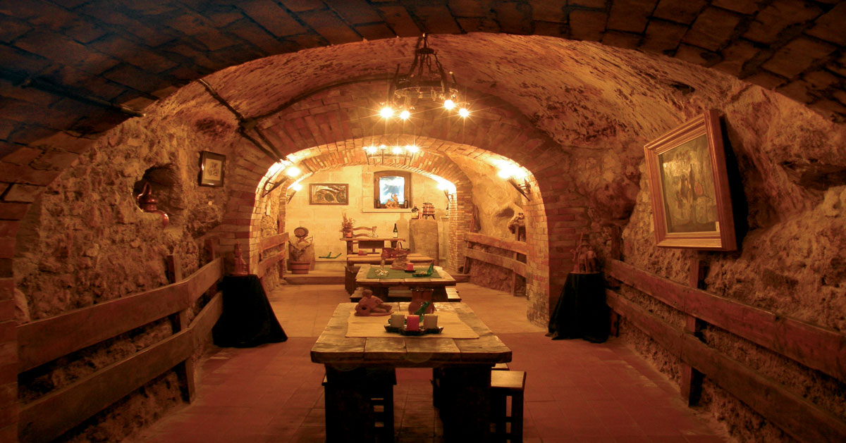
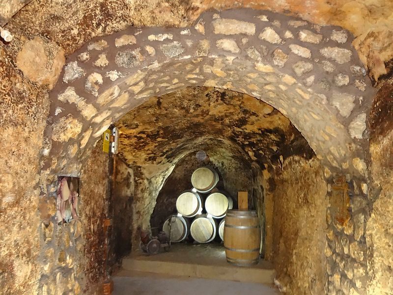
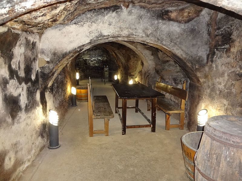
Used since the Middle Ages, there are currently about 135 cave-based wine cellars, or “bodegas,” under Aranda del Duero (many others have either collapsed or are no longer used for winemaking). The 5-mile-long network of caves is about 24 to 33 feet deep. Most of the cellars are interconnected and divided just by wooden doors.


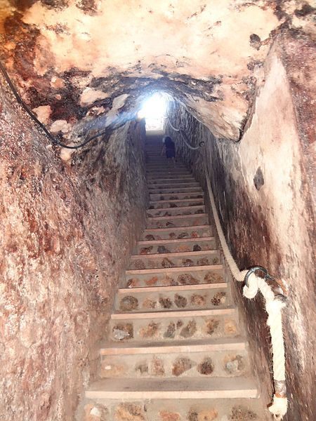
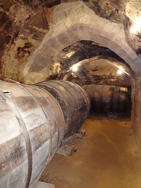
Many of these cavernous wineries offer guided tours and tastings, and obviously, all will try to sell you their wine (which is hard to resist). The winery of Don Carlos, built in the 15th century, invites visitors to explore the cave as part of a performance by costumed actors. Various clubs ó “peñas,” celebrate special events in these cellars and these clubs are clearly marked at street level. With a total length of around 7 km and excavated at a depth of 13m, the underground cellars of Aranda form the main tourist attraction of the city and undoubtedly show us part of the history of the Ribera del Duero.

The economy of the town, closely linked to wine, forced the locals of the 14th and 15th centuries to dig the cellars under their houses producing this network of incredible tunnels that were originally destined for the conservation of wines.

The medieval wine cellars of Aranda have a constant temperature and humidity throughout the year (if you happen to visit in the hot months, make sure you bring a jacket)

They possess an ingenious construction called zarcera, thanks to this, the historical cellars enjoy an excellent ventilation coming from the outside. These characteristics, together with the absence of noise and vibrations, made the wineries the ideal place for the elaboration and conservation of local wines until well into the last century.

The bodegas were designated as ”Assets of Cultural Interest” by the Spanish Government in 2015. 


https://www.bodegasdearanda.com/en/visitas-y-catas/


Like 5        Published at 12:07 AM   Comments (0)


Spanish - 4th Most Spoken Language in the World - Discover the others...
Thursday, December 2, 2021

What are the most widely spoken languages ​​on planet Earth? The initial ranking is fairly easy to guess. English and Chinese win, with their 1.1 billion speakers for each group. Following is Hindi, 615 million thanks to being one of the most populous countries in the world. Spanish is close behind with 534 million, French remains stagnant at 279, standard Arabic with 273, and so on and so on...

But almost more interesting than this is to be able to contemplate, with a single glance, the list of scopes, ramifications and genealogies of the languages ​​of the first positions. This evolutionary diagram has been created by Wordtips, developers of language-related tools for when you need to expand vocabulary or improve your Scrabble game. The legend of this map is comprised of the eleven main families and their subsequent branches (only Indo-European has up to 59) until reaching each language; the sum of native and total speakers of each language and the final ranking of the number of speakers.

Here are some initial and surprising observations: while most families end up in a hodgepodge of splits, Hungarian, Japanese and Korean are each their own cultural island. Despite being the language with the most total speakers within the entire Afro-Asian family, Modern Standard Arabic is one of the very few that lacks native speakers, caused by being a vehicular device to maintain a series of common registers in the Arab world (It is the same for the Filipino and the Nigerian Pidgin).

Also, for example, you can see how Greek has remained practically involutional for thousands of years, while the other classic pillar of Western civilization, Latin, found in romance a way to emerge into a multitude of categories that have been turned into things as varied as French and Romanian.

Despite the details of the graph, it does not reflect even one-hundredth of all the languages ​​spoken on the planet: it is estimated that there are around 7,097 different languages, although 90% of them are spoken by communities of less than 100,000 inhabitants.


Like 3        Published at 1:00 PM   Comments (4)


Spam post or Abuse? Please let us know


This site uses cookies. By continuing to browse you are agreeing to our use of cookies. More information here. x