If you have ever caught a coach across the raw, rust-red expanse of Timanfaya National Park or sipped a chilled glass of crisp dry Malvasía wine on a vineyard terrace in La Geria, you know that Lanzarote looks like nowhere else on Earth. It is an alien landscape of jagged malpaís (badlands), jet-black volcanic lapilli, and silent volcanic craters.
.jpg)
Yet, this lunar terrain is not ancient. Three centuries ago, southwest Lanzarote was the island's breadbasket—a lush patchwork of fertile cereal valleys, grazing pastures, and bustling hamlets.
All of that was wiped off the map starting on 1 September 1730, triggering a cataclysmic, relentless volcanic crisis where rivers of molten basalt ran continuously for six years, burying over twenty villages and permanently altering the geography, economy, and soul of the island.
Unlike prehistoric volcanic events reconstructed purely from rock strata, the Timanfaya cataclysm is documented in terrifying eyewitness detail. The parish priest of Yaiza, Father Andrés Lorenzo Curbelo, kept a meticulous diary recording the birth of the monster on that fateful late-summer evening:
"On the first day of September 1730, between nine and ten o'clock at night, the earth suddenly opened near Timanfaya, two leagues from Yaiza. An enormous mountain rose from the bosom of the earth, and from its apex flames escaped and continued to burn for nineteen days..."
The mountain that Curbelo watched burst out of flat farmland was the Volcán del Cuervo (Raven’s Volcano)—the initial fissure of an eruptive sequence that would defy all expectations.
Rather than a violent explosion followed by immediate calm, Timanfaya kept venting. As the weeks rolled on, fresh fissures tore open across the Santa Catalina plain. Curbelo recorded blinding ash storms that blotted out the midday sun, sulfurous clouds that dropped scalding rain, and toxic gases that suffocated livestock in their pens.
Whenever the terrified residents crept back to inspect their homes, a new crater opened, forcing wave after wave of desperate retreats.
Six Years of Chaos: The Timanfaya Timeline (1730–1736)
Between 1730 and 1736, more than thirty distinct volcanic vents roared to life along a 14-kilometre fracture line, spewing roughly three to five billion cubic metres of lava and tephra:
-
September 1730 (The Awakening): The Cuervo volcano erupts, spewing fire for nearly three weeks and burying the settlements of Timanfaya, Maretas, and Santa Catalina.
-
Late 1730 to 1731 (The Advance to the Ocean): Magma rivers plunge into the Atlantic, creating boiling steam geysers, blanketing the sea with thousands of dead fish, and creating new headlands that expanded the physical landmass of the island.
-
1732 to 1735 (The Great Exodus): With roughly a quarter of Lanzarote's surface smothered under metres of black basalt, over twenty settlements—including Tingafa, Mancha Blanca, and Las Palmas—are erased forever. A majority of the island's population flees by boat to Gran Canaria and Fuerteventura to escape starvation.
-
16 April 1736 (The Final Gasp): The eruption cycle finally grinds to a halt at Montaña Colorada after 2,055 consecutive days of volcanic activity. It remains the second-largest basaltic fissure eruption in recorded human history, surpassed only by Iceland’s devastating Laki eruption in 1783.
-
A Cloud That Travelled to the Pyrenees
The environmental reach of the Timanfaya eruptions extended thousands of miles beyond the Canary archipelago.
In a landmark study published in the scientific journal Science of the Total Environment, researchers examining ancient, centuries-old coniferous trees high in the Pyrenees mountains discovered distinct chemical signatures in tree growth rings dating to the 1730s.
The colossal sulfur dioxide and particulate plumes injected into the upper atmosphere by Lanzarote's six-year furnace drifted across mainland Spain, altering regional microclimates and leaving an indelible geochemical fingerprint in high-altitude mountain forests over 2,000 kilometres away.
The Timanfaya Effect: What Happened to Lanzarote
The 1730–1736 Eruption Legacy:
├── 23% to 25% of the island permanently buried beneath solid lava (malpaís)
├── 26 towns, hamlets, and fertile agricultural estates wiped off the map
├── 2,000+ islanders forced into permanent overseas exile
└── The Birth of 'Enarenado': The accidental invention of Lanzarote's dry-farming wine revolution
From Tragedy to Triumph: The Invention of Volcanic Wine
While the disaster caused unmitigated misery for 18th-century islanders, human resilience turned black ash into gold.
Farmers who returned to the scorched earth discovered an astonishing agricultural phenomenon: the thick layer of black volcanic pebble-sized ash, known locally as picón or lapilli, was naturally hygroscopic. It acted as an insulating sponge, absorbing humidity from Atlantic trade-wind mists at night while completely shielding the underlying soil from the scorching daytime sun.
Unable to plant traditional cereals, farmers dug thousands of deep, conical hollows (hoyos) into the ash fields of La Geria, planting single vine shoots down into the ancient soil beneath and encircling each hollow with a crescent-shaped stone wall (zoco) to deflect ferocious desert winds.
The result? The world’s most dramatic vineyard landscape, producing prized, mineral-rich volcanic Malvasía wines that now carry international acclaim.
How to Experience It Today
For anyone visiting or living on Lanzarote, walking the volcanic trails offers an extraordinary perspective on the raw power of nature:
.jpeg)
-
Volcán del Cuervo Walking Trail: The very spot where Father Curbelo saw the earth rupture on 1 September 1730 is now one of the island's most accessible walks. A gentle circular path leads right through the broken rim of the caldera into the heart of the crater floor.
-
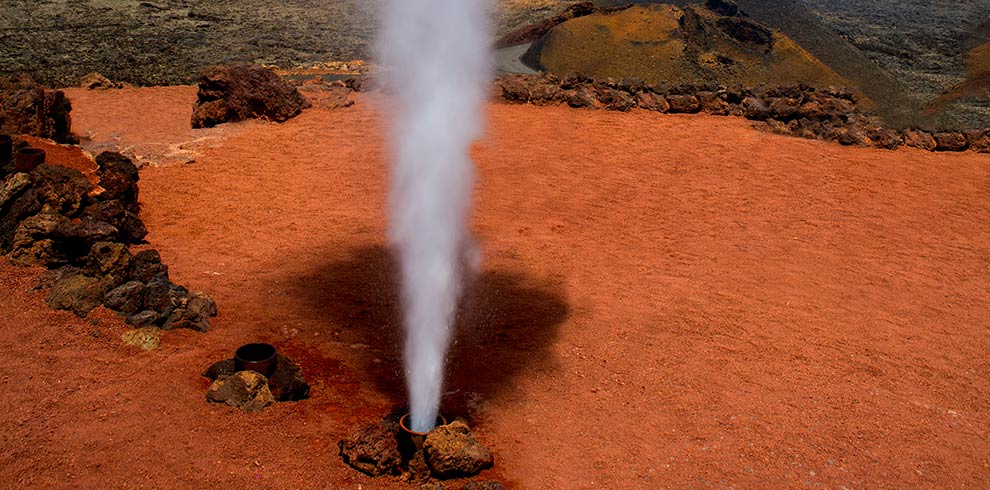
Montañas del Fuego (Timanfaya National Park): At the visitor centre designed by legendary local artist César Manrique, the ground beneath your feet still burns. Just ten metres below the surface, temperatures reach up to 600°C. Guides regularly demonstrate this geothermal heat by throwing dry brushwood into pits where it instantly ignites, or pouring buckets of water into boreholes that erupt into boiling steam geysers.
-
El Diablo Restaurant: Sample meats grilled solely by the convection heat rising from a natural volcanic chimney—a culinary reminder that the island's subterranean engine is merely resting, not dead.
Lanzarote's dramatic black beauty was bought at a devastating historical price. But next time you drive through Yaiza or raise a glass of chilled white wine in La Geria, spare a thought for Father Curbelo and the 18th-century islanders who watched their world vanish into fire—and ended up creating one of the most remarkable destinations on the planet.